Cadair Idris Walking Guide: Routes, Difficulty, Myth & Tips
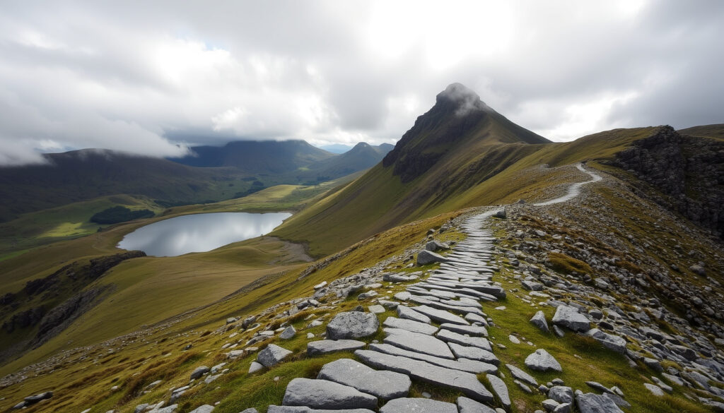
Few Welsh mountains stir the imagination quite like Cadair Idris. Its jagged profile dominates the southern edge of Eryri (Snowdonia) National Park, drawing hikers who want a serious day out without the queues that sometimes snarl Snowdon’s summit.
Height: 893 m (2,930 ft) ·
Location: Southern Eryri (Snowdonia) National Park, Wales ·
Prominence: 608 m (1,995 ft) ·
Main routes: Minffordd Path, Pony Path, Fox’s Path ·
Typical ascent time: 3.5–6 hours ·
Difficulty grade (Eryri scale): Hard
Quick snapshot
- Height confirmed at 893 m by Eryri National Park (park authority) and Ordnance Survey
- All three routes classified as ‘Hard’ on the Eryri difficulty scale per Visit Wales (official tourism body)
- Fox’s Path includes a Grade 1 scramble near the summit, confirmed by multiple walking guides (Eryri National Park (park authority))
- Exact completion times vary significantly – Visit Wales estimates 5–6 hours, but individual fitness and weather can swing this
- The precise origin of the ‘poet or madman’ summit myth is debated among folklorists
- Cadair Idris was designated a National Nature Reserve in 1957, ensuring protected status
- Path maintenance and signage improvements continue under Natural Resources Wales management
- Visitor numbers expected to grow; car park upgrades at Dôl Idris are under discussion by Eryri National Park Authority
- Expanded route information and digital maps are being developed by Natural Resources Wales
| Specification | Value | Source |
|---|---|---|
| Height | 893 m (2,930 ft) | Eryri National Park (park authority) |
| Prominence | 608 m (1,995 ft) | Ordnance Survey data |
| Grid reference | SH 711 130 | Ordnance Survey data |
| Range | Eryri (Snowdonia) – southern edge | Natural Resources Wales |
| Number of main routes | 3 | Visit Wales (official tourism body) |
| Nearest town | Dolgellau (about 5 miles north) | Natural Resources Wales |
Is Cadair Idris More Difficult Than Snowdon?
It’s a common question, and the answer is not a single number. Both mountains are graded ‘Hard’ on the Eryri difficulty scale, but the type of difficulty differs substantially. Visit Wales (official tourism body) confirms all three routes up Cadair Idris are strenuous, while Snowdon’s wider selection of paths includes easier options like the Llanberis Path, which is graded ‘Medium’.
Height and ascent comparison
Four key differences, one pattern: Snowdon is taller but Cadair Idris is rougher underfoot.
| Metric | Cadair Idris | Snowdon (Yr Wyddfa) | Source |
|---|---|---|---|
| Height | 893 m (2,930 ft) | 1,085 m (3,560 ft) | Eryri National Park (park authority) |
| Prominence | 608 m (1,995 ft) | 1,039 m (3,409 ft) | Ordnance Survey |
| Eryri difficulty grade | Hard (all routes) | Hard (most routes) | Visit Wales (official tourism body) |
| Typical round-trip time | 5–6 hours | 6–8 hours | Visit Wales guides |
| Path surface | Looser scree, steeper in sections | More consistent but longer ascent | Walking guide analysis |
Technical difficulty and scramble sections
- Snowdon has more consistent steep sections; Cadair Idris has looser scree near the summit, especially on the Fox’s Path.
- The Fox’s Path on Cadair Idris includes a Grade 1 scramble – a step up in technical difficulty that most Snowdon routes don’t require.
- Eryri National Park (park authority) warns that the Minffordd Path, often considered the standard route, may include sections of scrambling, particularly near the summit ridge.
Cadair Idris is 192 m shorter than Snowdon, but the combination of loose scree, steeper final sections, and a scramble option on Fox’s Path means its hardest route is technically more demanding than Snowdon’s hardest non-scramble paths.
How Long Does It Take to Climb Cadair Idris?
Time estimates vary by route, and official sources give slightly different numbers. Visit Wales (official tourism body) says the round trip should take between five and six hours for any of the three main routes. Visit Mid Wales (regional tourism authority) gives more granular data: the Minffordd Path is about 10 kilometres and approximately three hours to the summit, while the Llanfihangel y Pennant path is 16 kilometres and about seven hours round trip.
Route-by-route time estimates
Three routes, three distinct profiles – the distance doesn’t tell the whole story.
| Route | Distance (round trip) | Time estimate | Source |
|---|---|---|---|
| Minffordd Path | 10 km (6.2 mi) | 4–5 hours | Visit Mid Wales (regional tourism authority) |
| Pony Path (Llanfihangel y Pennant) | 16 km (9.9 mi) | 5–7 hours | Visit Wales |
| Fox’s Path | 11 km (6.8 mi) | 4–6 hours (includes scramble) | Walking guide estimates |
Factors affecting time
- Fitness and experience: Eryri National Park (park authority) states the Minffordd Path is only suitable for experienced country walkers with a good level of fitness. Beginners should expect significantly longer times.
- Weather conditions: Mountain weather changes quickly. A clear forecast can turn to cloud and rain within 30 minutes, reducing visibility and slowing pace.
- Route conditions: Loose scree near the summit on all routes can slow descent, especially for less experienced hikers.
- Car park fee: Dôl Idris car park charges £3 for 4 hours and £6 all day – useful to factor into your planning.
Most hikers who aren’t rushing the summit can expect a full half-day commitment. The Minffordd Path is the quickest option, but only if you know your limits and the route well. For a beginner, plan for the upper end of every time estimate.
What Is the Myth of Cadair Idris?
Before you lace up your boots, it’s worth knowing the story that hangs over this mountain. Cadair Idris – which means ‘the Chair of Idris’ – is steeped in Welsh mythology, centred on the giant Idris, a figure described as a poet, astronomer, and warrior. According to folklore, Idris carved his seat into the mountain’s summit ridge, where he would sit to observe the stars.
The legend of the giant Idris
- Idris is said to have been a giant of great wisdom who used the mountain as his astronomical observatory.
- The name ‘Cadair Idris’ directly references his chair – some local accounts describe a rock formation on the summit resembling a throne.
- The myth is well-documented in Welsh folklore collections and remains one of the most popular stories associated with the Eryri mountains.
Sleeping overnight and becoming a poet
- The most famous version of the myth claims that anyone who spends a night on the summit of Cadair Idris will wake either a poet or a madman.
- Some folklorists trace this belief to the 18th and 19th centuries, when bards would undertake night-time vigils on mountains as part of spiritual or creative rituals.
- The myth is also loosely linked to the legend of King Arthur’s court – some versions suggest Idris was one of Arthur’s knights or counsellors.
The catch: the precise origin of the ‘poet or madman’ variant is debated. What’s clear is that the story has endured for centuries, adding a layer of cultural weight to an already imposing mountain. For hikers, it’s a reminder that Cadair Idris carries significance that goes beyond elevation gain.
Is Cadair Idris a Scramble?
The short answer: only if you choose the right route. Eryri National Park (park authority) warns that the Minffordd Path may include sections of scrambling, particularly near the summit ridge. But not every route requires hands-on climbing.
Routes with scramble sections: Fox’s Path
- The Fox’s Path is the only route that clearly includes a Grade 1 scramble near the summit. Grade 1 means you’ll use your hands for balance and stability on exposed rock, but ropes are not required.
- Visit Wales (official tourism body) notes that all paths to the summit have a scramble just before reaching the top – the final push involves steep, rocky ground where you’ll need both hands.
- Walkers with scrambling experience will find Fox’s Path a rewarding challenge; beginners should avoid it.
Non-scramble route options
- The Minffordd Path is primarily a hiking route with no required hands-on climbing, though Eryri National Park (park authority) describes it as “hard/strenuous” with steep sections.
- The Pony Path (also called the Llanfihangel y Pennant path) is the longest but most gradual option. Visit Mid Wales (regional tourism authority) notes it is “probably the easiest route for most of the way, although it is also the longest.”
- None of the routes are waymarked above the lower slopes – Walk Snowdonia (walking guide resource) emphasises that navigation skills are essential, especially in poor visibility.
If you’re confident on the Minffordd Path but tempted by Fox’s Path for the views, be honest about your scrambling experience. The Grade 1 section isn’t extreme, but it’s exposed and requires good footing. Hikers who underestimate it risk a difficult retreat, especially in wet conditions.
Can a Beginner Climb Cadair Idris?
This is the question every first-timer should ask, and the answer comes with caveats. Eryri National Park (park authority) states the Minffordd Path is “only suitable for experienced country walkers with a good level of fitness.” That’s official guidance. But ‘beginner’ covers a wide spectrum – from someone who walks regularly on hills to someone who has never carried a map.
Best beginner route: Minffordd Path
- The Minffordd Path starts from the Dôl Idris car park, is well-marked at the start, and has a steady but relentless gradient. It is the most direct and most popular route.
- Visit Mid Wales (regional tourism authority) confirms it is “the easiest of the three summit paths but also the longest” – this applies to the Pony Path rather than Minffordd, which is shorter but steeper.
- Walk Snowdonia (walking guide resource) recommends beginners start early, carry a map and compass, and be prepared for all weather conditions.
Safety tips and recommended gear
- Navigation: None of the routes are waymarked above the lower slopes. A map (OS Explorer OL23) and compass are essential – don’t rely on phone GPS alone.
- Footwear: Good walking boots with ankle support are non-negotiable. The terrain is rough, with loose scree and steep sections.
- Clothing: Waterproof jacket and trousers are mandatory, even on days with a clear forecast – conditions change rapidly above 600 m.
- Fitness: Good cardiovascular fitness is essential. The climb gains roughly 650 m of elevation over 5 km on the Minffordd Path, which is a sustained effort.
- Check the weather: Mountain Weather Information Service (MWIS – mountain forecast specialist) provides specific forecasts for the Eryri ranges, updated daily.
Which Are the Main Cadair Idris Walking Routes?
Three official routes reach the summit, each with its own character. All are classified as ‘Hard’ by Visit Wales (official tourism body). The choice depends on your fitness, scrambling comfort, and how much time you have.
Minffordd Path
- Distance: 10 km round trip
- Time: 4–5 hours
- Difficulty: Hard – steep gradient, loose scree near summit, possible scramble sections
- Start point: Dôl Idris car park (grid ref: SH 728 115)
- Key feature: Starts through a beautiful woodland with a waterfall (Rhiw Goch waterfall), then climbs steeply to the summit ridge.
- Source: Eryri National Park (park authority)
Pony Path (Llanfihangel y Pennant path)
- Distance: 16 km round trip
- Time: 5–7 hours
- Difficulty: Hard – long but more gradual gradient
- Start point: Ty Nant (grid ref: SH 663 099) or Llanfihangel y Pennant
- Key feature: The longest route, but Visit Mid Wales (regional tourism authority) says it is “probably the easiest route for most of the way” and “reasonably safe” with “the most rewarding views.”
- Source: Visit Wales
Fox’s Path
- Distance: 11 km round trip
- Time: 4–6 hours
- Difficulty: Hard – includes Grade 1 scramble near summit
- Start point: Dôl Idris car park (same as Minffordd Path, diverges after the lake)
- Key feature: The most direct and technically challenging route. The scramble section is exposed and requires good footing.
- Source: Walk Snowdonia (walking guide resource)
Family-friendly options
- The Minffordd Path up to the saddle (around the 600 m mark) is a good option for families who want a half-day walk without committing to the summit. The waterfall at the start, the lake (Llyn y Gadair), and the dramatic cliff views make it rewarding even if you turn back.
- Visit Wales advises that the full summit hike is not suitable for young children due to the steep, loose terrain near the top and the unmarked paths.
- Eryri National Park (park authority) recommends that parents ensure children are experienced hill walkers before attempting any route.
Related reading: Kitchen Worktops Ireland Guide · Electric Motorbikes Ireland
en.wikipedia.org, livefortheoutdoors.com, walkupsnowdon.co.uk, deepreport.uk, beckythetraveller.com, adventurebrits.co.uk, publicreport.uk, thebaldscrambler.co.uk, rotterdamanalyse.nl
Hikers comparing routes will find the Cadair Idris hiking guide especially useful for planning their ascent.
Frequently asked questions
Is there a car park at Cadair Idris?
Yes, the main car park is Dôl Idris at the base of the Minffordd Path and Fox’s Path (grid ref: SH 728 115). It charges £3 for 4 hours and £6 all day. Ty Nant provides parking for the Pony Path. Both can fill up by 9 am on weekends and bank holidays – arriving early is strongly advised.
Do I need a map to climb Cadair Idris?
Yes. Walk Snowdonia (walking guide resource) emphasises that none of the routes are waymarked above the lower slopes. You need OS Explorer OL23 (Cadair Idris & Bala Lake) or a digital mapping app with offline downloads, plus a compass and the skills to use them.
Is Cadair Idris open all year?
Yes, the mountain is open year-round as public land managed by Natural Resources Wales. However, winter conditions can make routes dangerous, with ice, snow, and high winds. Check the MWIS (mountain weather specialist) forecast before any winter attempt. Crampons and ice axe may be necessary in winter conditions.
Can I take a dog up Cadair Idris?
Dogs are allowed on open-access land, but the terrain is challenging. The steep, loose scree near the summit can be tough on paws and requires your dog to be fit, confident on rock, and under close control. Livestock grazes on the lower slopes – keep dogs on leads through these sections.
What should I wear to climb Cadair Idris?
Waterproof jacket and trousers, walking boots with ankle support, and multiple layers (base layer, mid-layer, insulating layer) are essential. Eryri National Park (park authority) advises that even on a warm day, summit temperatures can be 10°C lower than the valley with strong winds. A hat, gloves, and spare warm layer in your pack are wise.
Is there a waterfall on the Minffordd Path?
Yes – the Rhiw Goch waterfall is one of the highlights of the Minffordd Path. It’s located in the wooded section near the start, about 1 km from the car park, and provides a natural rest point before the climb steepens.
More related posts
 The Customer Is Always Right Full Quote: Origin and Myth
 Lakes Hotel and Spa Windermere: Dress Code, Spa & Reviews
 Naomi Osaka: Biography, Mental Health & Identity
 Jack Doherty: Arrest, Net Worth, Girlfriend, and Biography (2025)
 Is Dyslexia a Learning Disability – Definition, Symptoms & Facts
 Emma D’Arcy: Partner, Gender, Career and Facts
 How to Make Slow Cooker Sausage Casserole Perfect Every Time
 Morocco National Football Team Games – Schedule, Results and Fixtures
